San Francisco-based Point One Navigation has introduced a new Tags feature to its Polaris network to streamline the development and deployment of precise positioning systems for various applications, such as surveying, construction, ag-tech, robotics, drones and autonomous vehicles (AVs).
The new tagging system is designed to address the logistical challenges faced by companies that rely on large-scale positioning solutions. Traditionally, deploying and managing fleets of drones, rovers or satellite receivers has involved engineering effort, requiring the integration of vendor data, synchronization with customer systems and ongoing infrastructure management. These processes can result in months of work and substantial costs, according to Point One.
Mark Wilkerson, Point One Navigation’s product manager, said, “The most powerful aspect of our tagging system is that it fundamentally changes the way customers can integrate their systems with ours.”

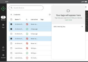
Point One’s tagging system enables customers to interact with Point One’s API as if it were a native application. It is is designed to enable the attachment of customer-specific data to Point One’s devices, allowing simple querying using native IDs, model numbers, regions and other parameters.
The system, according to the company, also eliminates the need for complex data integration steps, facilitating real-time operations through the GraphQL subscriptions API. The new tagging feature enables Point One Navigation’s Polaris network to make precise positioning accessible and manageable for any fleet size.
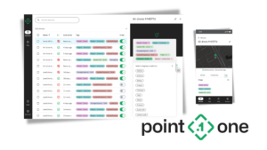
Point One Navigation has also introduced a device search interface in its web application which allows users to filter and query devices by tags, connection status or attributes, providing support teams with real-time visibility of active devices. Fleet managers should be able to efficiently retrieve information about specific device types or business units, with changes updated instantaneously across the web app and API.

Wilkerson added, “We’re always looking for ways to innovate and make the Polaris solution more intuitive and user-friendly. With tags, we’ve made it that much easier to attain fleet-scale precise positioning.”


